Tag Archives: Missouri River

Biking Back to Work

After lunch today, I decided to bike back to work. Non-motorized bike. It was good. I’ve been around the sun well over 45 times, now, and the lure of incremental healthy (and fun) decisions has overridden any other decisions that seemed to intersect with the metabolic rate of my 20s and 30s. I’ve also been recalling in my memory some time ago hearing the phrase, “Well, every 7 years we are somebody different than we were 7 years prior.” That also links up with the understandable IRS requirement of retaining 7 years of records (kind of non-related aside). While on my ride, I was thinking about where I was 7 years ago, on the planet, and frame of mind. It indeed was different. None of which really is necessary to go into here (maybe it’s kind of secular spiritual for everyone to think of where they were 7 years ago, keeping it to themselves of their own record).

While pumping the pedals of the bike, I also enjoyed how much more audible the urban setting is from historic downtown Bismarck to the Missouri River front (audible even while my bluetooths allowed me to hear Ray Cappo discuss his spiritual journey through India in the early 1980s and such).

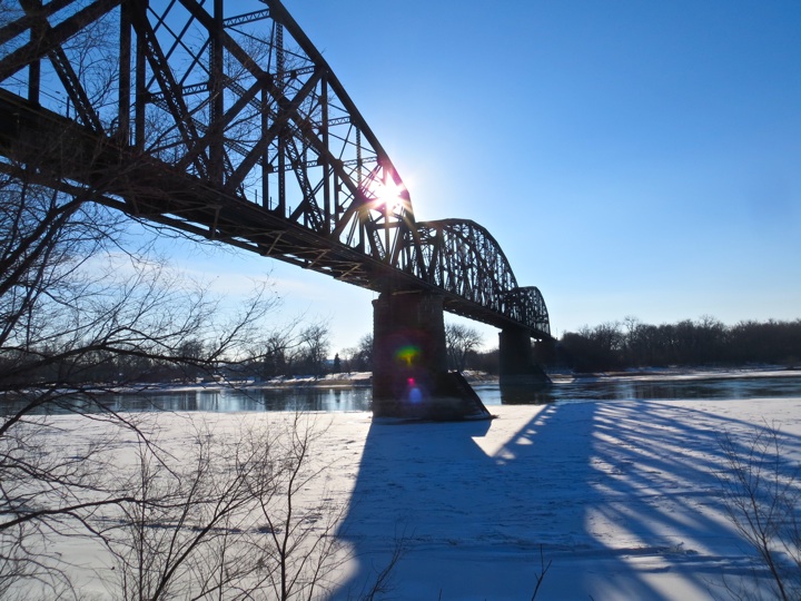
Photo below is from the Chief Looking Village overlook (Chief Looking Village was one of several interconnected Mandan-Hidatsa villages circa 1500s). In the photo you can see the horizontal light blue Interstate 94 bridge that spans the Missouri River at Bismarck (check out the Missouri River Heritage Mural on the visible pier at left). In the distance, with all the floating cranes, you can see the Ames contractors of BNSF, the floating cranes, as they are ramming pilings into the river to build a new rail bridge that can accommodate stacked rail cars for all those one-click Amazon orders that bring stuff from the Pacific World to Chicago, and everywhere in between. Once finished, BNSF will disassemble the 1905 bridge superstructure and the 1883 rail bridge piers (they were built with Minnesota granite). It will change the landscape viewshed of the river. Off in the distance of this photo, mid-right, you can see little dots on the horizon butte. Those little dots are the 1930s Civilian Conservation Corps reconstructions of the 1870s Fort McKeen/Fort Abraham Lincoln (today’s busiest state park in all of North Dakota). Bottom center you can also see the contour of a mountain bike trail, one of many that our Burleigh County Bicycle Cult friends maintain for everyone’s overland bicycling pleasure.


Bighorn and Little Bighorn Confluence

In the latter afternoon hours of this last Tuesday, May 15, 2018, I found myself at the confluence of where the Little Bighorn River empties into the Bighorn River in southeastern Montana. It was the first time I had been to this spot. And I stared at it for a while.

The Situation Circa June 1876

The National Park Service Little Bighorn/Greasy Grass map.

This is the location where Cpt. Grant Prince Marsh parked the steamer Far West and waited under orders of General Terry for the outcome that would go down in history as the Battle of Little Bighorn/Greasy Grass.

Confluence of Little Bighorn and Bighorn Rivers

This is the approximate location where Captain Grant Prince Marsh secured the Far West steamer under orders of General Terry.

At the time of the action, Marsh and crew and the Far West were 15 miles from it all. Marsh’s biographer, Joseph Hanson, noted that Marsh and crew tied up the Far West at this approximate location to wait for the outcome. The waters had become too shallow to go any further. It required more than 3′ of depth.

During the wait several of the Far West crew took to fishing. And they could see little contours here and there of smoke and/or dust rise up out of the horizon.

We know what happened. And it is always a fascination to view history from the infinite perspectives it can afford us. It’s similar to or just like listening to someone else’s experience that we will never be able to experience ourselves. We sit and listen. We wonder what it was like.

When I came across this location, the one thought that cleared up in my mind was how Cpt. Marsh initially could not confirm the correct location of the Little Bighorn River in his ascent up the Bighorn River.

Water moves fairly swift, at least at this time in mid-May. Marsh operated in a pre-dam world, too. In June and late-June.

Boots and LBH River Mud

What the Redwing boots look like after making it to the confluence of the Little Bighorn and Bighorn rivers. There is no rival when it comes to eastern Montana mud. It is the best mud out there. The best.

Once he was informed of what had happened, he ordered the crew to cut grass and lay it on the Far West deck. Then he ordered that to be covered with sheets. All of this was in anticipation of the wounded who would be put on the Far West. 

Once boarded, Marsh set off and set a never-again-to-be-accomplished record of making it to the Missouri River shores of Bismarck, Dakota Territory, in the late-late hours of July 5, 1876.

From there the officers swiftly made their way a mile up to what is today the historic downtown of Bismarck to wake Col. Lounsberry, the owner and publisher of The Bismarck Tribune. 

Lounsberry then communicated what happened by telegraph to the New York Herald, and from there the story fired around the world.

I still have Little Bighorn-Bighorn river mud on my Redwing boots from this last May 15 outing.

Bismarck Tribune and Far West

The Far West was a part of the Coulson Line on the upper Missouri River. This is an ad the Coulson Line ran in the Bismarck Tribune during the Dakota Territorial years.


Winter Hike on the Upper Missouri River Bottoms

I snapped some photos this last Saturday during a hike along the upper Missouri River bottoms. Here is a brief collection of some of the shots.

The Missouri River bottoms just below Mandan-Hidatsa Chief Looking Village in Bismarck, North Dakota.

The Missouri River bottoms just below Mandan-Hidatsa Chief Looking Village in Bismarck, North Dakota.

The second photo is the historic steel truss railroad bridge that spans Bismarck-Mandan, and it reminded me of the aesthetics that today are appropriated by steam-punk artists. If you want to know what steam punk might be, click here on this link.

A close up of the historic railroad bridge spanning Bismarck-Mandan.

A close up of the historic railroad bridge spanning Bismarck-Mandan.

This next photo is an overview of the railroad bridge, with the winter sun setting in the late-afternoon.

Historic railroad bridge, looking west toward the winter sun getting ready to set.

Historic railroad bridge, looking west toward the winter sun getting ready to set.

And this final photo is of the icefishing that takes place on the Missouri River at the Grant Marsh boat landing. The I-94 Grant Marsh Bridge is also in the photo, but it does not look 1/64th as nice as the historic steel truss railroad bridge from three and four generations ago.

Ice Fishing